ecpi.common.instru.model_geom module
Section author: ECLAIRs GP team
Geometric description of the X-ray instrument
Summary
Classes:
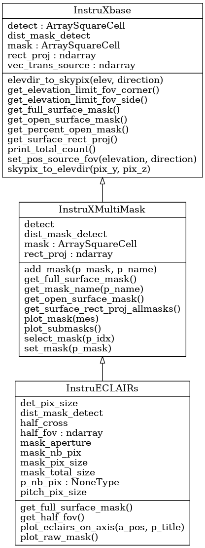
Implementation of the ECLAIRs mask geometry in ECL_Los referential |
|
To manage multiple mask for X-ray instrument |
|
Base class for X-ray instrument mask convention : 1 for hole, 0 stop photon |
Class diagram:
Reference
-
class
InstruECLAIRs(p_file_mask=None, p_nb_pix=None)[source]¶ Bases:
ecpi.common.instru.model_geom.InstruXMultiMaskImplementation of the ECLAIRs mask geometry in ECL_Los referential
-
class
InstruXMultiMask(p_detec: ecpi.common.num.array_square_cell.ArraySquareCell, p_dist_mask_detec)[source]¶ Bases:
ecpi.common.instru.model_geom.InstruXbaseTo manage multiple mask for X-ray instrument
-
add_mask(p_mask: ecpi.common.num.array_square_cell.ArraySquareCell, p_name=None)[source]
-
-
class
InstruXbase(p_mask: ecpi.common.num.array_square_cell.ArraySquareCell, p_detec: ecpi.common.num.array_square_cell.ArraySquareCell, p_dist_mask_detec)[source]¶ Bases:
objectBase class for X-ray instrument mask convention : 1 for hole, 0 stop photon
-
elevdir_to_skypix(elev, direction)[source]¶ convert elevation/direction coordinates into sky pixels coordinates
(0,0) is at the center of the sky array
- Parameters
elev (float or array(float)) – elevation in degrees
direction (float or array(float)) – direction in degrees
- Returns
pixels y,z coordinates
- Return type
float, float or array2D(float)
-
get_elevation_limit_fov_corner()[source]¶ for special case where mask and detector are square and with the same center return deg
-
get_elevation_limit_fov_side()[source]¶ for special case where mask and detector are square and with the same center return deg
-
get_surface_rect_proj()[source]¶ compute intersection detector and shadow mask then compute its surface
- Returns
intersection surface in cm2
- Return type
float
-
set_pos_source_fov(elevation, direction)[source]¶ set definition of the translation vector linked to the source vec_trans_source is also position on mask where photon passed to go on origin
-
skypix_to_elevdir(pix_y, pix_z)[source]¶ convert pixel coordinates into elevation and direction
(0,0) is at the center of the sky array.
elevation from 0 to 90. direction from -180 to +180
- Parameters
pix_y (float) – y coordinate of the source, in pixels.
pix_z (float) – z coordinates of the source, in pixels.
- Returns
elevation and direction of the source in deg
- Return type
float, float
-